The War Years
(World War II)
The area of Westward Ho! was of use during the 2nd World War.
The beach was used for a number of training exercises including development of:
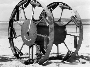
The Great Panjandrum
As plans for the attack on Northern France took shape in 1943 Group Capt. Finch-Noyes attached to HQ Command Operations brought a rough sketch of a weapon to Norway(better known as Neville Shute).
Two steel wheels each 10 feet in diameter with tread a foot wide, connected by a drum like axle, which contained high explosives and would be propelled by a large number of slow burning cordite rockets fitted around the circumference of each wheel,It would be carried by a tank –landing craft. The rockets would ignite when the ramps went down and propel itself through the shallow water and up the beach to the wall like a giant Catherine Wheel reaching a speed of 60 miles and hour by the time it struck the bastion.
A firm of engineers and building contractors called Leytonstone were given the plans and Norway christened the monster ‘’PANJANDRUM’’ because the gunpowder ran out from its heels.
On August 3 1943 the construction began in great secrecy in a hut at Leytonstone works.
In Appledore the Combined Operation Experimental Establishment known as COXE had been set up to try out all manor of invasion projects.
Westward Ho! was the ideal rehearsal area with the gradient of the open beach and the tidal conditions similar to the ones across the channel. The nearby coast offered every kind of trial for the raiding party or main landing force.
Appledore had its long open sea, beaches and high surf and within the Estuary mud, shingle sand dunes and rock.
- September 7 was decided to launch the Panjandrum on its maiden run
- September 27,October 26, November 12 more trials
- Early January 1944 they next assembled at Westward Ho!
The Panjandrum which they loaded into the Landing Craft was almost a reversion of the original prototype in appearance, with just the two 10ft wheels, the axle chamber (ballast with 2 tons of sand) and no steering gear fitted.
The Panjandrum was given a preliminary run with 48 rockets in position and a speed of 65 mph was hoped for-but this time it mysteriously failed to reach even 50 mph over a measured 800 yards.
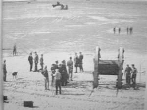
After lunch a resplendent gathering of Admirals and Generals made their way to the pebble ridge, a number of distinguished scientific observers were present too.
Whitehall had come to pass judgement on The Great Panjandrum, and the wheezers and dodgers,(as the people of the Weapon Experimental department were known )sensed this trial would decide its fate.
The Panjandrum made a slow impression start, in the first few yards the inevitable rocket burst free from the clamps, two more broke free, but now the Panjandrum was moving at a terrific speed, a rushing inferno of smoke and jets of fire. At 80 yards the monster crossed the line of craters and the shore side which dipped ominously. At 120 yards the awed watchers realised it was out of control, it began to swing in a great curve to starboard, heading to the pebble ridge, the VIP’s flung themselves headlong down the far side of the pebbleridge, expecting the monster to come hurtling over the brow and crush them all. Seconds passed and nothing happened- they crawled back up the stony slope and from the ridge they saw that The Great Panjandrum was in its death throws. It had swung back to seawards and crashed over on its side on the sand. This smothered the rockets underneath but the others continued to explode, wrenching and distorting the whole frame until the remainder burst from their fittings and screamed off along the beach in every direction.
Various eminent authorities were consulted, but it proved impossible to overcome the two major defects and the project was reluctantly abandoned.
Maybe it was never meant to be used and the trials were a smoke screen, where the landings eventually took place there were no barriers which The Great Panjandrum was supposed to go through.
The Northam burrows, behind the ridge, were used to house a series of radar equipment and associated aerials.
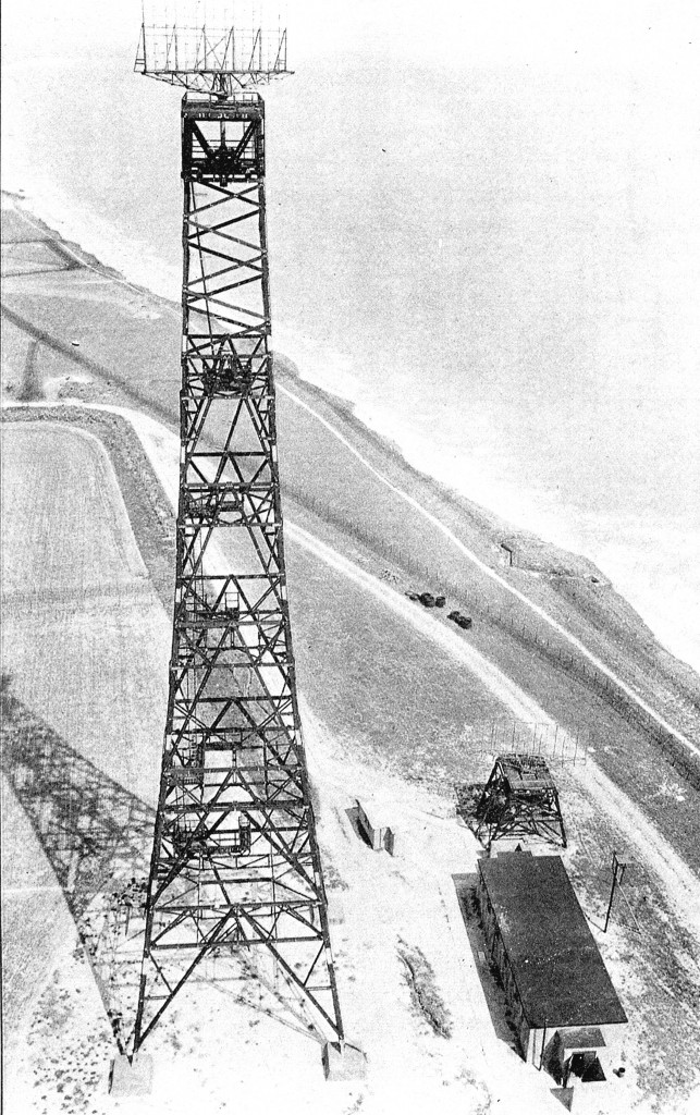
The Air Ministry chose Northam as a location for a ‘Chain Home Radar’ site, which was a station capable of detecting aircraft at long ranges.
There were two pairs of 235 feet high transmitting masts, with a curtain array between each pair:
Further photographs can be seen on the ‘Richard Sumner Memories‘ page
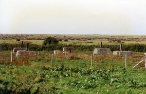
The stumps are still visible today:
There were a number of buildings, again some present still today: (better photograph needed)

“Northam Chain Home Radar Station” is now a Grade II listed building.
On the Historic England site the description is as follows: (copyright acknowledge)
Summary of Building
Second World War radar station, built 1941 and ceased operating in 1944. The site includes two transmitter blocks, two receiver blocks, the bases of two receiver tower and four transmitter masts, a substation, and structures associated with either an Advance or an Intermediate Chain Home and are dispersed over an area of some 24ha.
The two associated decoy targets situated on Northam Burrows are a scheduled monument.
Reasons for Designation
Northam radar station, which operated between 1941 and 1944, is listed at Grade II for the following principal reasons:
* Degree of survival: as a substantially intact Chain Home radar station which retains its principal buildings, tower and mast bases, and other related structures; which allow a clear understanding of how the site functioned; * Historic interest: as a physical manifestation of tensions and fears during the Second World War, which resulted in the establishment of a chain of radar stations to protect Britain’s coast; * Group value: for its strong visual and spatial relationship with two associated decoy targets (recommended for scheduling).
History
The introduction of aircraft as an offensive weapon provided the rationale for strategic air defence systems adopted by Britain from the early 1920s. These systems initially involved early warning, based on the visual spotting and tracking of aircraft, but developed through acoustic detection devices to radar. Following experimental work at Orfordness and Bawdsey Research Station in Suffolk (which became the prototype site for the Chain Home Defence System and where different components are listed Grade II and II*), the Air Ministry completed the first group of radar stations in the summer of 1938 in the South-East as an early warning of air attack on the country. In recognition of the importance of radar stations in providing long-range early warning, the network was expanded along the east and south coasts and, the outbreak of the Second World War, to other parts of the country including the South-West. Only aircraft at fairly high altitudes could be tracked by this method, however, and low-flying aircraft or surface shipping could not be detected. To overcome this, a second chain, more or less alternating with the first and integrated into the same reporting system, was created and known as the ‘Chain Home, Low’ (CHL). Information gathered at the sites would be passed to Fighter Group HQ at RAF Bentley Priory where enemy aircraft locations were plotted and a response was co-ordinated. Radar was adapted during the Blitz of 1940-1 to incorporate a system of Ground Controlled Interception by which night fighters were controlled directly by each station rather than via a central operations room. A further addition in 1941 was Coast Defence/Chain Home Low, a low-cover coastal radar designed to detect surface shipping. Many stations were converted in 1942 to new and more powerful equipment, known as Chain Home Extra Low. Finally, in 1943, Fighter Direction radar was developed to aid Fighter Command in their offensive sweeps over occupied Europe. Many radar stations were reused during the Cold War period for Rotor, a Cold War re-engineering of wartime radar equipment and later replacement with new designs.
The chain home radar station at Northam came into operation by early 1941 and was one of twelve permanent stations established in Devon during the Second World War. As with other West Coast stations, it differed in layout from the southern and eastern sites, and consisted of a group of dispersed buildings in order to avoid all the operational buildings being hit should an air attack occur. A group of four brick-built structures in the central part of the site possibly relate to an Advance or an Intermediate Chain Home and were erected while Northam’s permanent radar station was under construction. An Air Ministry drawing of 1941 showing proposals for the underground cabling at Northam provides details of the layout of the radar station which comprised two transmitter and two receiver blocks, with duplicate equipment in each, and several ancillary buildings including a standby (generator) set house (at NGR SS4534530192, demolished early C21) and a substation. The transmitter aerials were mounted on two pairs of 325′ guyed steel masts (Air Ministry Experimental Station, AMES type 1) located to the north of the station buildings, and the receiver aerials were mounted on two 240′ timber towers located close to the receiver blocks. A domestic complex including dining rooms and barracks which was constructed to the south-west of the technical site was demolished in the late C20.
By May 1944 as the German bomber threat receded, and because of the high cost and manpower required to keep the Chain Home network operating, the stations underwent a rapid contraction. From a peak of 194 stations in 1944, by 1947 only 36 remained, with only 29 of those manned at full readiness. Northam was placed on care and maintenance in 1944 but never resumed service. Its transmitter masts and receiver towers were dismantled shortly after the war.
Details
Second World War radar station, built 1941 and ceased operating in 1944. The site includes two transmitter blocks, two receiver blocks, receiver tower bases, transmitter mast bases, a substation, and structures associated with either an Advance or an Intermediate Chain Home and are dispersed over an area of some 24ha.
DESCRIPTION: The two RECEIVER TOWERS, which were wooden, self-supporting 240 foot (73.15m) towers have been demolished, but aerial photographs of 1945 and 1946 show them in situ. The four tapering, concrete anchor blocks or feet, embedded with metal struts, remain in situ and mark the position of the two towers (NGR SS 44495 29852 and SS 44765 29940). At the centre, between each of the four blocks is a cable junction box which has four brick corner piers and a concrete cap. Metalwork protrudes from concrete.
The two Type C RECEIVER BLOCKS (NGR SS 44582 29735 and SS 44858 29788) are rectangular structures measuring approximately 14m north-south by 10m west-east. They are built of reinforced concrete, sealed with a thick bitumen-type layer, and were originally surrounded by an earth mound or traverse for blast protection. The traverse to the west receiver block (SS4458229735) has been removed. Each receiver block has entrances to the west and north elevations which have concrete blast or wing walls. A tall concrete ventilator protrudes from the roof of the west block; that to the east is obscured by vegetation. The interior is divided into a number of rooms, some with brick walls, but not all the rooms could be inspected. However, as the layout generally followed a standardised form (built to Air Ministry drawings) it is clear that these included a receiver room as well as rooms occupied by air filtration equipment, a telephone exchange, storage and a WC. The original colour scheme of yellow and green paint survives in the east receiver block, as do a number of simple wooden architrave and part of the original air conditioning arrangements. The latter would have allowed air to circulate around the building (which would require temperature modification given the machinery operating inside) but would prevent debris coming into the system in the event of external blasts. The modern timber stable partitions within the central room are not included in the listing.
The four TRANSMITTER MASTS (AMES type 1, centred on NGR SS44962 30302), which were paired, were constructed in a line and built of steel lattice (the Northam transmitter examples were supported by steel guy ropes and therefore are technically masts rather than towers: towers were used on east and south coast Chain Home sites and were self-supporting). The bases for the masts survive and thus mark their locations. Each was held in position by aerial halyards which were anchored to large concrete blocks set into the ground; there are four pairs of blocks for each mast. Other features include a winch base and concrete halyard balance weights which would have counterbalanced the weight of the aerial curtains that were suspended between each pair of masts.
The two Type C TRANSMITTER BLOCKS (NGR SS 45120 29963 and SS 452943 0400) housed the transmitter equipment which delivered pulses of high frequency energy from antenna erected on the four steel transmitter masts located on the Burrows to the north. They are roughly square structures, measuring some 9m west-east and 10m north-south, and are built of reinforced concrete which has been sealed with a thick bitumen-type material and encased by an earth mound or traverse for blast protection. Each building has two entrances which are protected by concrete blast wing-walls and there are two concrete ventilators on the top of the mound. The west receiver block has heavy timber-clad, steel doors to its main entrance; adjacent to this is the transformer room. There is a second entrance to the north elevation. Within the building, the central area housed the transmitter, while the air filtration plant was sited in the adjacent room. There are metal fittings to the ceiling of the plant room and some of the ventilation trunking also survives. The east transmitter block was not inspected internally. To the south-west of the west transmitter block is the SUBSTATION (NGR SS 44940 29859). It is a flat-roofed building that is constructed of reinforced concrete which retains some of its bitumen-type covering; its earth traverse has been removed. It has three entrances to its north-west, south-west and south-east elevations; each leading to a separate room, none of which interconnect. The four brick structures, centred approximately on SS 44753 29959, are probably the remains of either an Advance or an Intermediate Chain Home (ACH and ICH respectively) which was erected and operated while the permanent buildings were under construction. The two largest structures are blast or retaining walls which have lost much of their protective earth mounds, and within each is a central concrete base, probably for a temporary wooden hut. Abutting one of the larger structures is a large concrete base and two plinths which may be the remains of a generator house. The smaller two buildings have flat concrete roofs and may have been a sentry or lookout post and a shelter.
Here is a newspaper article describing the removal of the masts:

Links to memories of the war years by:


